On this page...Updates on Otterburn Mill tenter restoration|Survey of tenter sites|Examples of associated mills and tenters|Tenter terraces|Gallery.
Modern remains
This page presents photos of some of the tenter remains evident today, and adds a little more detail to some examples.
It also briefly presents the result of a survey of 6-inch to the mile OS maps from the 1840s and 1850s maps for Lancashire and the West Riding that show the locations of tenters, and whether there is any evidence today of their former presence.
Otterburn Mill tenters
RESTORATION OF OTTERBURN MILL TENTERS - UPDATES: The banner photograph on the Home page of the field tenters at Otterburn Mill was taken in September 2017. Unfortunately, the site was flooded in 2019 and 2020 and the tenters were damaged. The owner Euan Pringle and staff sought a grant from The National Lottery Heritage Fund. They were awarded £85,158 in November 2023 to restore the frames, in association with several heritage organisations and individuals.
I contributed a report on the historical importance of the tenters and concluded that in England, there are no largely intact field tenters still standing in their historical setting, except at Otterburn Mill. They are a unique relic of a fundamental process essential to the manufacture of woollen cloth, a trade that had a profound impact on the historical prosperity of this country.
Available for download are a press release from Otterburn Mill, and a copy of my report.
The images below were taken part-way through the renovation and shows work by conservation joiners. Where possible, they installed splice joints to replace severely damaged sections. For wooden rails beyond repair, new Douglas Fir rails were being installed. A blacksmith had been identified to make tenterhooks (information courtesy of Louise Shaw).
Please be aware that in mid-June 2025, it was announced that Otterburn Mills Limited had gone into voluntary liquidation, with the loss of 28 jobs, and had ceased trading. My understanding is that the site, including the tenters, is not open to the public.
The last update I received from the Mill was in January 2025, when the work on the tenters was about half-way through. This would be followed by building works to make paths, landscaping etc. The likely final completion was June 2025. I was due to visit in July 2025 to discuss the works, but the liquidation thwarted the visit. I do not know the status of the work at this time (June 2025).
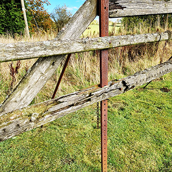
The Otterburn tenters are reasonably intact (bearing in mind their age) but the floods exacerbated their decay. Shown here is particularly serious damage.
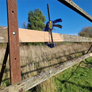
Splicing damaged rail.
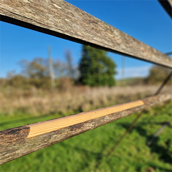
Spliced damaged rail.
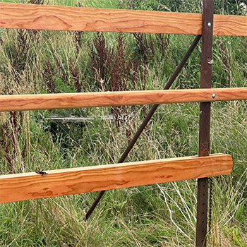
Replaced rails - the originals beyond repair. Tenterhooks are not yet installed in the lowest rail (beam) in the photo, which is adjustable to stretch cloth (the fixed top beam is out of shot and will also have tenterhooks installed).
More stone tenters in Marsden
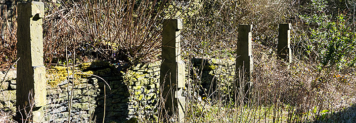
Relict unusual stone tenter-posts at Crowther Bruce Mill Road, Marsden. Note the upper slot to accomodate adjustment of the wooden beam (now gone) for different cloth widths. Commonly, the lower mount is the adjustable one.
Survey of tenter sites and remains in woollen districts of East Lancashire and the West Riding of Yorkshire
Tenters were depicted on the mid-nineteenth century First Edition six inches to the mile Ordnance Survey (OS) maps of Lancashire and the West Riding. Each sheet was 24 square miles (6 x 4 miles). The West Riding six inch OS surveys took place in 1844-54, and within Lancashire in the period 1842-49. A review was undertaken to determine the British National Grid references of tenters marked on sheets of the woollen industry districts. A 'site' was defined as tenters in an individual enclosure, which may have single or multiple seams. Tenters in adjacent enclosures were classed and counted as separate sites.
For each site, the modern terrain was determined by inspection of satellite images and classed as built-over, pasture/meadow, woodland, parks etc. Any evidence of tenter remains, principally tenter-banks usually evident as single or parallel lines that corresponded to the tenters marked on the First Edition maps, was visited, photographed and superficially surveyed.
West Riding
Sixty-six sheets were reviewed, encompassing the area due south and west from the Harrogate/Knaresborugh sheet (154) to the Riding boundary. This area encompassed the principal yarn and cloth manufacturing area of the Riding. A total of 312 tenter sites were noted on 19 sheets; the largest number of sites on a single sheet was 60 (sheet 232: north Dewsbury). Many of the sites shown within fields on the First Edition six inch maps are now covered by housing and industrial developments, however 78 former tenter sites (25 per cent) are currently pasture, garden, park, allotments or scrub and were amenable to survey by satellite for remains. Only six sites showed linear features that matched some or all of the seams shown on the historical mapping.Lancashire
Seventy-three sheets were reviewed in the north and east of the historical county, having excluded those to the due west and south from sheet 54 (Ribchester), principally the plains of the former moss areas. Seventy-one sites were noted, 30 of which had not been built over. Six of these showed satellite evidence of tenter-bank remains.
Summary
On the evidence of six-inch OS mapping from the 1840s and 1850s in the two counties, only 12 (3%) of the 383 tenter sites had evidence from aerial imaging of tenters identified as parallel or single lines reflecting the map evidence. On the ground, there were no standing or delapidated tenter structural remains. Even in these 12, tenter-banks were difficult to identify at ground level in some cases. Of the total tenter sites shown on the mapping, 72% had been covered by the built environment.
Examples of associated mills and tenters
Wall Hill tenters
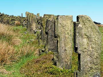
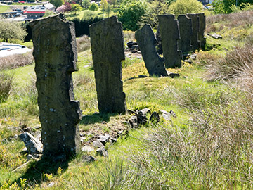
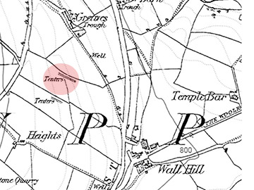
These are remarkable remains of stone tenter posts near Wall Hill, Dobcross. The notch at the top would hold the fixed upper bar of tenterhooks, the extended notch below housed the mobile lower bar to adjust the width. The posts were marked on the mid-nineteenth six-inch OS map (shaded red). The single set of tenters to the south have gone.
Local poet and historian Ammon Wrigley wrote in 1940 (Ref. 1):
'c. 1840. Stone Tenter Posts erected at Wall Hill. Height 6 feet. Weight about one ton each. Probably one of the most remarkable outdoor industrial relics in England. Greaves and Cooper, flannel manufacturers, Wallhill.'
Mike Buckley from the Saddleworth Historical Society advised that:
'Trade directories show that Robert Greaves of Wall Hill was in business as a flannel manufacturer from the 1830s to 1860s and there were a James Cooper and a Robert Whitehead Cooper, both of Wallhill, in business at the same time; James also a flannel manufacturer. However the directories give no indication of a partnership.'
Genealogist Jane Sheehan undertook further research on my behalf: a Robert Greaves, woollen weaver, is listed in the 1841 census in Wall Hill. James Cooper and Robert Cooper were both found in the 1841 census returns living at Wall Hill and both working as clothiers. Two Coopers are listed the 1822 Baines History and Directory, West Riding (p. 262 Saddleworth), under the trade heading 'Woollen Cloth Manufacturer' (but not Robert Greaves) - Robert Whitehead Cooper, Wall Hill and Joseph Cooper, Wall Hill.
In 1834 Pigot’s Directory (p. 906 Saddleworth) under the trade heading 'Woollen Cloth Manufacturers' there are two individuals with the surname Cooper and nothing for Greaves. The two Cooper woollen cloth manufacturers listed are not classed as merchants - James Cooper, Wall Hill and Robert Whitehead Cooper, Wall Hill. There was no listing of a Robert Greaves or the Coopers at the Greaves and Heights farms/cottages close to the tenters in the 1842 and 1851 censuses (but a Thomas Greaves, labourer, was at Greaves in 1851, brother-in-law to the Head and his wife, Jonathan (and Mary) Bradbury, woollen manufacturer).
The Yorkshire Archaeological Society Journal has a short article on the tenters (Ref. 2).
Longden End Mill tenters
The mill was near Rakewood, Rochdale. The tenters were still present on the 1891 survey (six-inch map) but not shown on the 1904 revision; the mill was marked as 'disused' on this map.
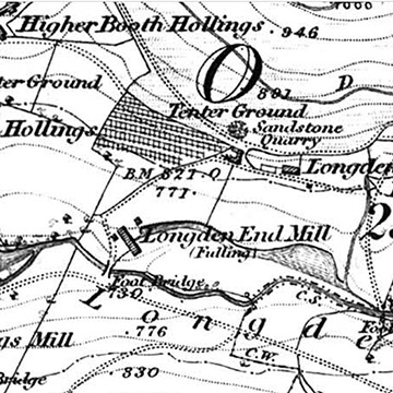
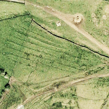
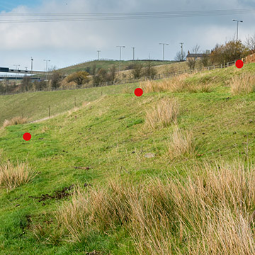
Tenters near Longden End fulling mill. Left - Tenters marked north of Longden End Mill, 1840s map. Centre - tenter site remains on Google Earth. Right - some of the remaining tenter-banks, marked.
In the 1851 census, a James Clegg was at 'Longdenend' and was a 'fulling miller employing 11 hands' (he had six sons, five of whom were 'fulling millers'. 'Longdenend Mill' was occupied by Thomas Denton (carter), his wife, a coal miner, and a woollen piecer. For sale in 1871 (Rochdale Observer, 23 Dec 1871), the mill had a steam engine, steam boiler, water wheel, five rows of double tenters, four single, drying 'stone' [stove?] with eighteen lengths and six lengths tenters inside. In 1891, Longden End was occupied by a John Leach and family, described in a 1891 trade directory (Cotton Spinners & Manufacturers Directory), as a 'finisher of all classes of woolen and angola shirtings, white goods etc.' In June 1894 he was fined £5 for polluting a stream that fed the river Roach and told the court that he was fitting tanks and filter beds to tackle the problem. (Manchester Courier and Lancashire General Advertiser, 7 Apr 1894).
The mill was destroyed by fire in 1906; at the time it was owned by Messrs. Whitworth, woollen cloth finishers (Cotton Factory Times, 27 Apr 1906). There are currently just a few stones at the mill site, but the reservoir/filter beds are still evident.
Oil Mill tenters
The mill was at the hamlet Lydgate near Littleborough on the old packhorse route from Rochdale to the Halifax area. In 1851 the locale was occupied by two families, the Holdens and the Kershaws, mainly woollen workers - fullers, carders, piecers, spinners and weavers, and a third family not associated with the industry, the Butterworths. In 1861, the heads of three families were all fullers, with the head William Rothwell employing 8 men and 2 boys. In 1871 the breadwinners were again all fullers/millers. In Jan. 1883 the London Gazette published proceeedings for liquidation instituted by William Spencer and Charles Rigg of the Oil Mill. The dominance of fullers in the families continued up until 1901/1911 when some were working in the cotton industry.
The 1891 25-inch OS map shows tenters closely associated with the mill, but the tenters shown in the 1840s are not evident. In 1909, the mill is marked as 'Disused'. The 1891 map shows a Lydgate Mill also in the hamlet, with it own tenter-fields. It was owned by Alfred and William Law, flannel manufacturers, who also had a mill in Littleborough. Although not shown on the 1840s map, it must have been built shortly after because in 1858 a partnership of Law and Fletcher of that mill was dissolved (London Evening Standard, 13 Feb 1858).
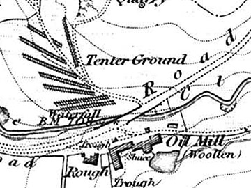
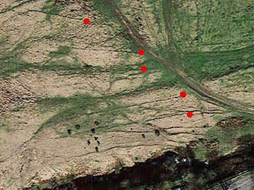
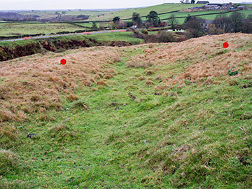
Left - the northern set of tenters for the 'Oil Mill' fullers. Centre - remaining tenter-banks aerial (the mill is just off the bottom right). The eastern (right) ends of the linear banks are marked. Right - the path between two of the tenter-banks going away from the camera. The tenter-banks are marked.
Tenters at Luddenden

The magnificent mill is Oats Royd Mill, Luddenden, Upper Calderdale, a former worsted mill, now dwellings. The business was founded by John Murgatroyd, worsted spinner, in the 1700s. The mill dates from 1847, but closed in 1983 (Ref. 3). Worsted was not normally fulled, and this mill is not the focus of our attention on tenters.
Less noticeable at the bottom of the image are very faint tenter-banks in a field. The red circles are on the left end of the racks, which extend to the right. These tenters are marked on the 1914 25-inch OS map (below), just south-west of Peel House Mills, the mill marked as 'Woollen'. The tenters are the parallel lines to the right of centre. The owners/tenants undoubtedly erected the tenters. There is a interesting photograph of the mill and its tenters, but I have been unable to contact the owner and so cannot show it. However a copy is on Malcom Bull's Calderdale Companion so click here to view the photo. Note the building (shed) in the tenter field, probably a wet-house (storing cloth in inclement weather). In 1925 when up for sale it was described as a 'blanket manufacturing plant', and two Whiteley tentering machines were available (Yorkshire Post and Leeds Intelligencer, 13 Jun 1925). At times in its history, it also functioned as a worsted mill. The mill today is a ruin.

As an aside, the author Whiteley Turner who wrote the wonderful book A Spring-Time Saunter: Round and About Brontë Land was sent to work in Peel House Mills when aged eight. The book recounts his walk from Mount Tabor (Luddenden) to Haworth and back in 1905; he chatted to local country people, including women who knew some of the Brontës in their childhood. When aged 13, his arm was torn off by a carding machine at a different mill (Halifax Evening Courier, 21 Feb 1921).
Tenter terraces
West Riding
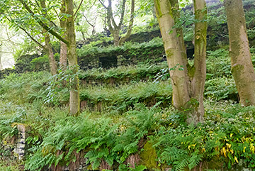
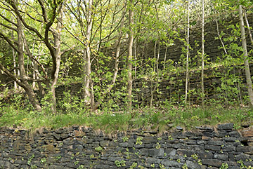
Terraces probably used for tenters. Left - Beverley End near Hebden Bridge, Right - Hollins Mill Lane, Warley, Sowerby Bridge.
Beverley End is a ruined weaver's cottage associated with Jumble Hole Clough, a steep former industrial valley with a number of mills (between Todmorden and Hebden Bridge). Interestingly, the dark rectangle is a bee bole (to hold bee skeps or wooden hives), one of twelve. Hollins Mill Lane terraces are part of the groundworks of the elevated Rochdale Canal just out of shot at the top of the photo. A survey and and local knowledge suggest the platforms were associated with the textile industry, dated to the end of the eighteenth century.
Chalford, Stroudwater, Gloucestershire
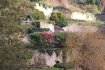
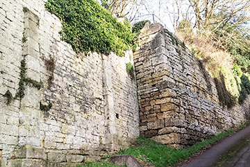
Left - Tenter terracing above the original site of Seville's Lower Mill in Chalford; Right - A retaining wall at the east end of the tenter terracing.
This part of Chalford (near Stroud) is a steep valley side upon which was Seville's Mill complex. It operated until about 1838 and the mills were demolished in 1842. It is now a residential area. The enormous tenter terraces above the mill still survive, some altered over the subsequent years by residents, constructing arches and recesses as garden features. The terraces were built for tenters. The massive retaining wall adjacent to the road indicates the size of the terraces. (Information and photographs courtesy of Trevor Ford, Chair of the Board of Trustees, Stroudwater Textile Trust.)
Gallery
This section presents larger copies of some of the key images (click to enlarge), and images of other tenters (and supposed tenters) not shown elsewhere.
-
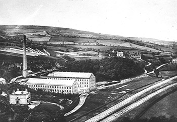
Stubbins Vale Mill, Rossendale, c. 1870
Woollen mill in the valley with its tenters on the hill above (behind the chimney). Courtesy of John Simpson, Helmshore.
-
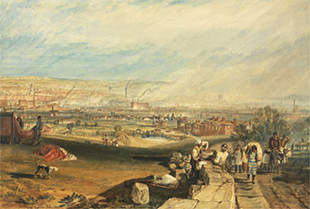
JMW Turner, 'Leeds', 1816
Dyed cloth on tenters (left), Beeston Hill, Leeds; travelling clothiers and other trades (right). Courtesy Yale Center for British Art.
-
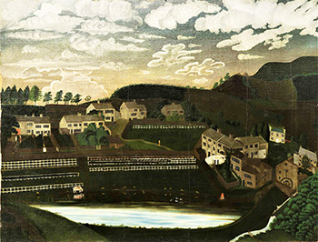
Tenters in Steps near Honley, 1829
'Steps near Honley' painted by Thomas Beaumont, 20 July 1829; Copyright a Private Collector.
-
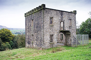
Tenter wet-house. Stubbins Vale
Tentering Tower (wet-house) at Stubbins Vale, Rossendale.
-
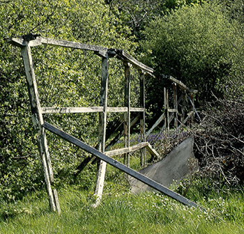
Tenter at St John's Mill, IOM
This tenter photograph was taken at St John's Mill in 1969. The derelict rack rotted away and was replaced by a demonstration rack around 2002. The tenter-field was used occasionally until the early 1970s (pers. comm. Bob Jeavons at the mill, now a venue for diverse events). Courtesy Ken Howarth, Heritage Photo Archive.
-
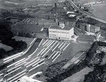
Wormald and Walker blanket mill, Dewsbury
Many seams of tenters drying and stretching blankets in the 1930s. The Yorkshire Film Archive has an interesting film from 1932 on the operations in the mill. It is free to view. Each piece contained 25 blankets, the number a man could carry. Each tenter-dried blanket could be sold with a maximum 15% moisture (to improve its 'feel'); this was achieved by putting the blankets in a cellar and spraying water on the floor.
-
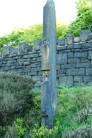
Isolated tenter-post, Butterley Reservoir, Marsden
It is probable that this solitary tenter-post was moved here. Nevertheless, it is an important relic. The spillway (overflow), near to the tenter-post is a magnificent structure.
-
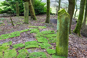
Tenters at Petty Royd, Pig Hill, Huddersfield?
These posts (more behind the camera) are described by some as 'tenters', associated with nearby clothiers' cottages, now ruined. They are unlikely to be cloth tenters but are probably 'tenters' for drying wool and yarn. On the more intact ones, there are metal loops embedded on the side and top (see left aspect of the nearest post). The loops would hold wire/rope to support the wool/yarn between posts.
-
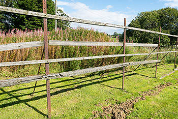
Otterburn Mill, Northumberland
The only original reasonably intact wood and iron tenters in England still standing in their historical location. There is some ambiguity in their dating - a sign at the mill says they date from the early eighteenth century but Historic England says early nineteenth. The latter is probably correct.
-
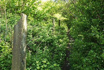
'Tenters' at Longwood Gate, Huddersfield
There are five 'tenter-posts' just up the track ftom the Slip Inn in Longwood. Rather damaged tops. There is no obvious facility to support tenter beams to stretch cloth; perhaps their role was to simply dry cloth after dyeing, or dry wool and yarn. Compare these with the posts at Petty Royd (above).
-
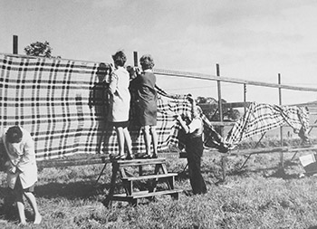
Tentering at Otterburn Mill
These tenters no longer exist. Undated but probably 1960s/1970s judging by the clothing.
-
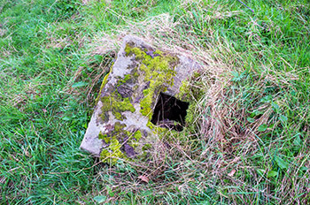
Tenter-post support
A stone tenter-post support remaining in a nineteenth century tenter field, Helmshore.
-
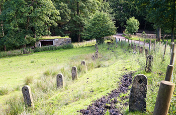
What are these?
A rather unusual set of posts that are associated with the ruined building in the distance (there is a post against the building's wall). They are near to the well-known Close Gate packhorse bridge (also known as Eastergate Bridge) on the outskirts of Marsden. The recesses suggest that 'stang' posts were inserted to form a cattle-proof walkway, or perhaps to form a support of sticks for a stretchergate.
-
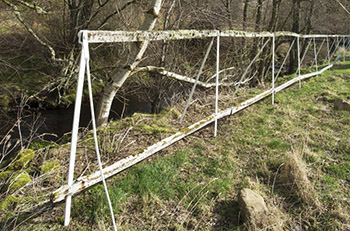
Rack of tenters at Knockando Woolmill, Scotland
Still standing. Seeking more information about it, but get no response from the mill. Recently restored. © Crown Copyright: HES.
-
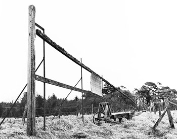
Tenter at Islay Woollen Mill, Scotland
Photo from 1979. I think it unlikely that this tenter is still standing, but having difficulty confirming this. No response from the mill.© Crown Copyright: HES.
-
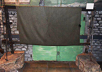
Tenter in storage at Lakeland Arts in Kendal
Kendal (Cumbria, formerly in Westmorland) was renowned for its woollen industry and tenters were widespread in the town and surrounding hills. This tenter came from High Tenterfell. Note that it is set in limestone blocks. The Lakeland Museum is temporarily closed but collection objects can be viewed by appointment. Photo courtesy of Lakeland Museum (Lakeland Arts).
-
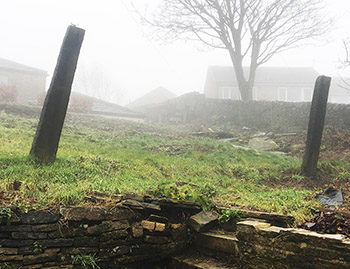
Recently discovered stone posts (2 of 3) at Stainland, West Yorkshire; field tenters?
Three stone posts were rediscovered when an overgrown area in the centre of the village was cleared, for a proposed building. The Parish Council and a local resident asked me to determine if these were field tenters. I don't think they are; I believe them to be 'wool posts' used to dry wool and yarn, similar to the posts at Petty Royd above (although of different design). My report on these intriguing relics is available for download. Photos and useful information from Cllr. Lisa Fieldhouse and local resident June Holden.